
Possible tropical cyclone will generate torrential rains in Guerrero and Oaxaca
Today the low-pressure zone with high cyclonic probability could evolve to a tropical cyclone off the coast of Guerrero, having a parallel displacement to the Central Pacific, in combination with the Intertropical Convergence Zone.
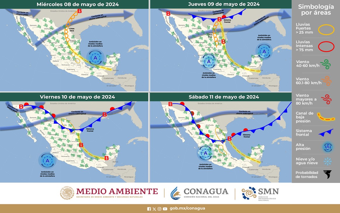
On the other hand, low-pressure channels in the interior of the country; one extended from the north to the center of the national territory, will interact with instability in height, a second on the east of the Republic, and a third on the Yucatan Peninsula. These meteorological systems will cause rain potential.
Heavy rains at torrential points (150 to 250 liters per square meter): Guerrero and Oaxaca.
Very heavy rains at intense punctures (75 to 150 liters per square meter): Michoacán, Jalisco, Veracruz, Chiapas, and Tabasco.
Heavy rain at very strong times (50 to 75 liters per square meter): Puebla and Campeche.
Heavy rain showers intervals (25 to 50 liters per square meter): Chihuahua, Durango, Sinaloa, Tamaulipas, San Luis Potosí, Nayarit, Colima, Querétaro, State of Mexico, Mexico City, Morelos, Hidalgo, Tlaxcala, Yucatán and Quintana Roo.
Showers intervals (5.1 to 25 liters per square meter): Zacatecas, Aguascalientes and Guanajuato.
Isolated showers (0.1 to 5.0 liters per square meter): Baja California, Coahuila and Nuevo León.
Minimum temperature forecast for today September 28, 2019:
Temperatures from 0 to 5 ° C: Sierras de Baja California, Sonora, Chihuahua, Durango, State of Mexico, Puebla, Hidalgo, Tlaxcala and Veracruz.
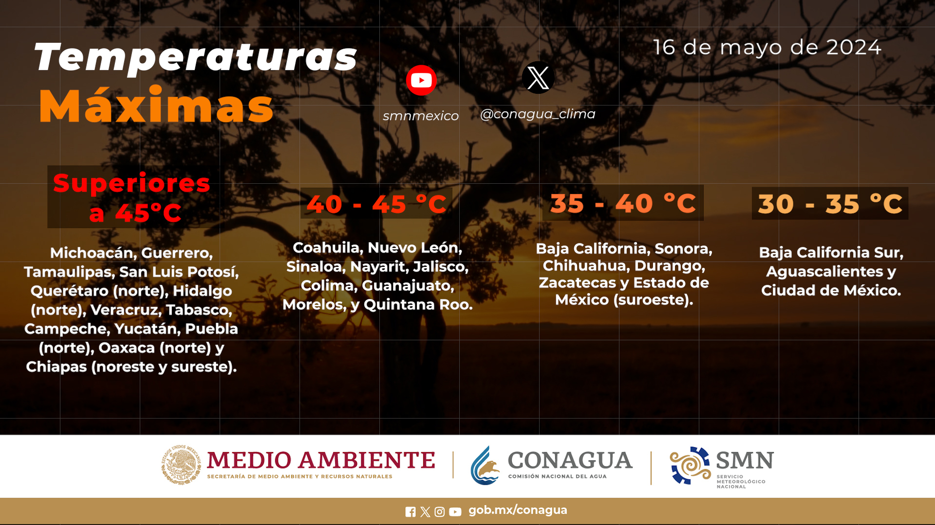
Forecast of maximum temperatures for today September 28, 2019:
Temperatures from 35 to 40 ° C: Areas of Baja California, Sonora, Coahuila, Nuevo León, Tamaulipas, San Luis Potosí, Sinaloa, Michoacán, Guerrero, Morelos, Veracruz, Campeche, Yucatán and Quintana Roo.
Wind with gusts greater than 60 km / h and waves of 2 to 4 m: Coasts of Guerrero, Oaxaca and Chiapas.
Winds with gusts greater than 40 km / h: Areas of Baja California, Baja California Sur, Coahuila, Nuevo León, Tamaulipas, coasts of Veracruz, Campeche and Yucatán.
Swell of 1 to 3 meters: Coasts of Nayarit, Jalisco and Colima.
Forecast by regions:
Valley of Mexico: Cloudy sky during the day, in the afternoon the cloudiness will increase and heavy point rains are forecast accompanied by electric shocks in the State of Mexico and Mexico City. East component wind from 10 to 25 km / h with gusts that can exceed 40 km / h. A maximum temperature of 24 to 26 ° C and a minimum temperature of 13 to 15 ° C is expected in Mexico City. For the State of Mexico, maximum temperature of 22 to 24 ° C and minimum of 7 to 9 ° C.
Baja California Peninsula: Partly cloudy sky with possible isolated rains in Baja California. Hot atmosphere in the afternoon. Northwest wind from 10 to 25 km / h, with gusts greater than 40 km / h on the western coast of the region.
North Pacific: Cloudy afternoon sky with heavy point rains in Sinaloa. Hot environment in the region and west component wind from 15 to 30 km / h.
Central Pacific: Cloudy sky most of the day, expecting heavy punctual rains in Michoacán and Jalisco, as well as strong in Nayarit and Colima, which will be accompanied by electric shocks. Warm atmosphere during the day and wind from the south and southwest from 10 to 25 km / h and waves from 1 to 3 meters off the coast of Nayarit, Jalisco and Colima.
South Pacific: Cloudy sky most of the day with torrential occasional rains in Guerrero and Oaxaca, as well as intense in Chiapas, which will be accompanied by electric shocks. Warm atmosphere during the day. Variable direction wind from 15 to 30 km / h with gusts greater than 60 km / h and waves from 2 to 4 meters high on the coasts of Guerrero, Oaxaca and Chiapas.
Gulf of Mexico: Cloudy sky and heavy punctual rains in Veracruz and Tabasco, and strong punctual in Tamaulipas, all accompanied by electric shocks. Hot weather during the day and east and southeast winds from 10 to 25 km / h with gusts greater than 40 km / h in Tamaulipas.
Yucatan Peninsula: Cloudy sky in the afternoon with very strong punctual rains in Campeche and strong Yucatan and Quintana Roo, which will be accompanied by electric shocks. Warm and windy atmosphere from the east and southeast from 10 to 25 km / h with gusts of 40 km / h on the coasts of Campeche and Yucatán.
Mesa del Norte: Partly cloudy sky in the afternoon with heavy point rains with electric shocks in Chihuahua, Durango and San Luis Potosí, intervals of showers in Zacatecas and Aguascalientes, as well as isolated rains in Coahuila and Nuevo León. Hot environment and variable direction wind from 10 to 25 km / h with gusts greater than 40 km / h in areas of Coahuila and Nuevo León.
Central Table: Cloudy sky with very strong punctual rains with electric shocks in Puebla, forts in Querétaro, Morelos, Hidalgo and Tlaxcala and intervals of showers in Guanajuato. East and northeast wind from 10 to 25 km / h with gusts of up to 40 km / h in storm areas.
Source: conagua
The Mazatlan Post


