
The rainy season begins in Mexico, with it the activation of different meteorological phenomena that are capable of causing strong storms and long periods of precipitation.
Although May is the peak month of spring, the rainy season also begins in some countries of Central America and North America; In the case of Mexico there are many reasons why this season is defined, one of them is the beginning of the hurricane season that was activated on May 15 in the Pacific basin, in its central and eastern region , directly influencing the western coasts of Mexico .
Likewise, the activation of other meteorological phenomena occurs , where influenced by effects such as thermal contrast and the dragging of moisture from both oceans, directly contribute to the increase in the amount of precipitation in the Mexican Republic. The National Water Commission (CONAGUA) indicated that the rainy season officially begins during the month of May and concludes in the month of November .
Among the most recurrent phenomena are: the troughs , electrical storms , mesobajas and tornadoes , to name a few, it is worth mentioning that many of these are related to each other or give rise to others. On the other hand, we also have the presence of waves from the east (tropical waves), coming from the coasts of Africa and reaching Mexican coasts, either as simple waves or developed as tropical depression, tropical storm or hurricane in any of its categories.
Also geographical factors such as orographic forcing, evaporation, windward slopes and the influence of vegetation, contribute to the origin of rainfall. The influence of large-scale phenomena or planetary scale in the same way contribute to the appearance of more rainfall, these can encompass large geographical regions or even continents, for example, the Madden Julian Oscillation (MJO, for its acronym in English).
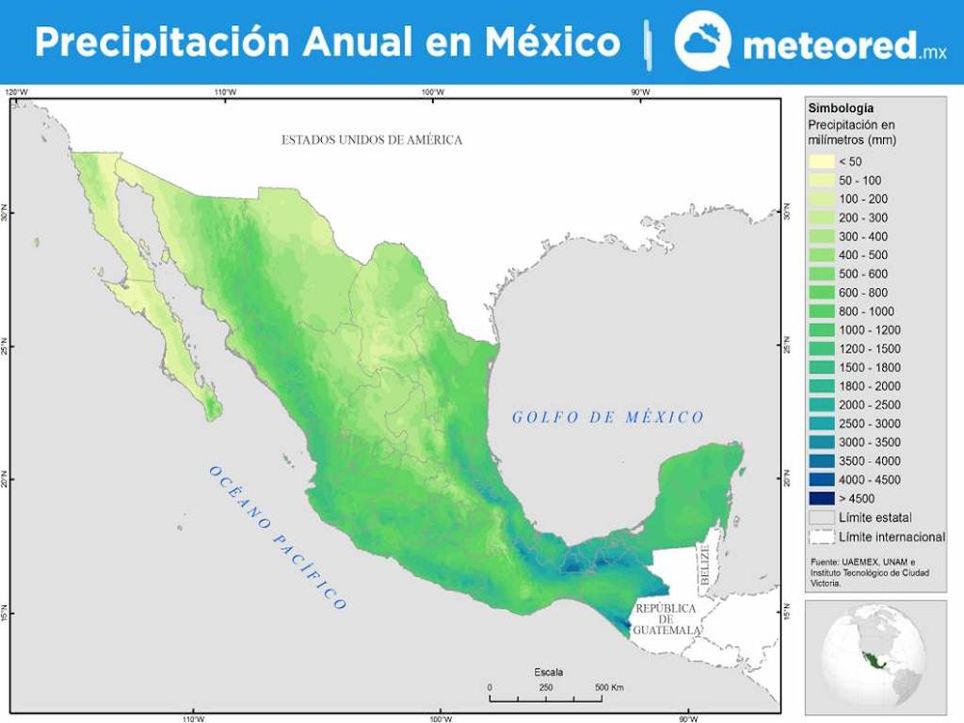
Distribution of rain in Mexico
The geographic distribution of the rain in Mexico is linked to its orography, for example, the mountains act as a wall that prevent the incursion of all the humidity carried by the winds in the troposphere, but at the same time at its other extreme they increase the amount of rain. rain in its slopes exposed to humid winds, effect reinforced by the rise and adiabatic cooling of the air .
On the other hand, tropical cyclones from both the Atlantic and the Pacific influence the maximum precipitation records in coastal littorals. At the end of summer and autumn is when it rains most in Mexico, because there is greater influence of tropical disturbances, being more frequent during September and October .
The most rainy area with values higher than 1500 mm of rain per year is found in the south of the country, due to the influence of the humid sea winds associated with the trade winds. The area with the highest rainfall is around 3500 mm and is located in the southeast portion of the Sierra Madre de Chiapas, is influenced by tropical cyclones from both oceans and the zitron of intertropical convergence (ITCZ) that reaches this region in September.
The driest part of the country is the northwest, there are areas in the state of Sonora that report less than 45 mm of rain per year and these are caused by some extratropical cyclones and the displacement of frontal systems. Meanwhile, in the highest part, which are the mountains in the center, west, and south, the precipitation can yield values that are around 1000 mm or more of rain per year.
Source: meteored
The Mazatlan Post


