

There are streams and canals, especially the Jabalines, which represent a risk for those who live near the riverbed.
MAZATLAN.- Every year, it is well known that Mazatlan floods, from north to south, and to measure the risk there are mechanisms that Civil Protection has at hand that help identify potentially dangerous areas. So keep reading, because you may find the name of your neighborhood or subdivision here.
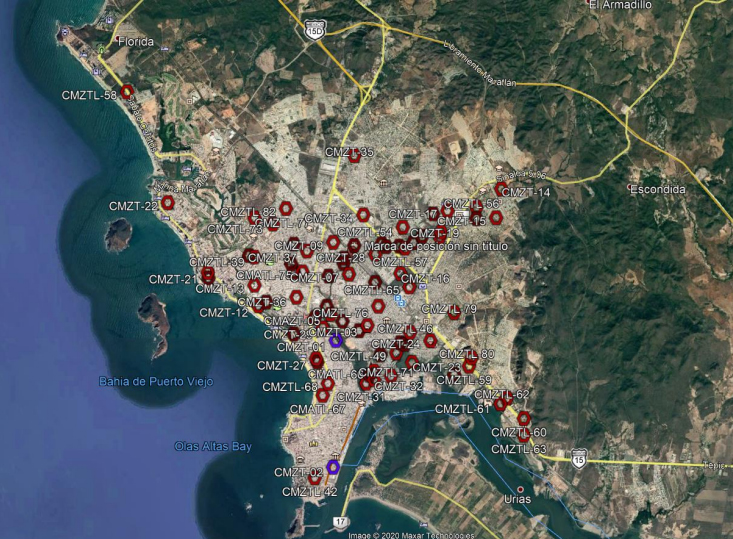
Within the urban area of Mazatlán, it is estimated that there are more than 80 human settlements prone to flooding due to the rains, in addition to the rural area, where there are more than 15 points at risk, thanks to the fact that they are near canals or streams.
Next, we present the neighborhoods susceptible to the risk of river flooding in Mazatlán.
Urban zone
The City Center, Lázaro Cárdenas, Benito Juárez, Toledo Corro, Rubén Jaramillo, Villas del Estero, November 20, Ramón F. Iturbide, Fovissste Mazatlán, Lico Velarde Extension, Playas del Sol, Flamingos, Alameda, Genaro Estrada, Villas del Sol, La Foresta and Villa Verde.
There are also other sectors such as Salvador Allende, Insurgentes, Tierra y Libertad, May 12, Casas Económicas, Bahías de Mazatlán, Valle Dorado, Hogar del Pescador, Infonavit Playas, López Mateos, Pueblo Nuevo, El Toreo, Francisco Villa, Anabella from Gávica, Playa Sur, Lico Velarde and Villa Verde.
Other points are Los Laureles, San Jorge, Gaviotas, Sábalo Country, Pino Suárez, Francisco I Madero, Rafael Buelna, Burócrata, Olas Atlas, Jacarandas, Anáhuac, Jesús García, Santa Cecilia and Azteca.
Rural zone
For their part, in the communities of the rural area that may be affected are from La Cofradía, El Tecomate, Escamilla, Lomas de Monterrey, San Francisquito, La Tuna, El Vinillo, El Pozole, La Urraca Vieja, Barrón, Siqueros, El Bajío , Lomas del Guayabo, El Roble, Villa Unión and El Walamo.
It is important and valuable that all the people who live in these points, heed the recommendations of Civil Protection and the different brigades, in addition to protecting valuable papers among other personal things.
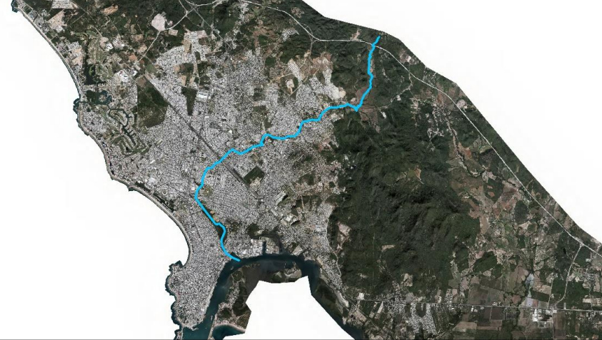
Javelins Creek
The Jabalines stream, whose channel flows for more than 11 km in the urban area of the city until its mouth at the Infiernillo estuary, is one of the main generators of floods due to the fact that it has undergone modifications in its natural form, which has caused this runoff overflows and causes damage to the population, businesses, industry and municipal infrastructure.
There are 94 human settlements on the main basin of the Jabalines stream, which represent the area most vulnerable to flooding, according to the Risk Atlas.
other streams
Jabalines 13.57 km long
Venadillo-cid 8.75 km long
San Marcos-allende 6.21 km long
Juarez-internacional-azteca 4.54 km long
Alborada-urias-mazindustrial 4.37 km long
San Antonio-Del Valle dam Munich-villa Verde 4.06 km in length
Universo-hda Victoriamzt 3-campo Golf-fco Ima 4.05 km in length
Bimbo-pemex-cafe Marino-jesus Garcia-azteca 2.95 km in length
Sanchez Celis-toreo-cid 2.43 km in length
Villa Tutuli-mañanitas-villa Verde 2.33 km long
Progreso-pradera 2.17 km long
Clouthier-melina-pemex 2.03 km long
Inf. Playas-jacarandas 1.97 km long
Camino Armadillo-pradera-progreso-torres Bodet 1.96 km long
Cruz Lga 1.85 km km long
La Raqueta-clouthier 1.70 km long
Chulavista-dorados De Villa-fed 3-av La Marina 1.59 km long
Fm-niños-heroes- Jesus Garcia 1.58 km long
Lcatsin-clouthier 1.24 km long
Valles Del Ejido-h Del Pescador 1.19 km long
Bicentenario-fco Villa 1.10 km long
Chololos-magueyes-chonita-Jabalines stream 1.10 km long
Fco. Villa- Av. La Marina 1.08 km long
Buenos Aires-mañanitas 0.65 km long
Reforma 0.62 km long
Felipe Angeles-francisco Villa 0.50 km long
Av. La Marina-home Depot 0.26 km long
The Mazatlan Post


