

The objective is to guarantee the safety of the attendees who come to the esplanade of the Plazuela República and Avenida Del Mar.
MAZATLAN.- If you don’t plan to go to the City Center, you better not go, because there will be road chaos.
The Government of Mazatlán, in coordination with the Ministry of Public Security and Municipal Traffic, has ready the preventive actions that they will implement during the operation on the night of September 15 in the city, on the occasion of the celebrations of the Shout of Independence and the Parade Civic of September 16.
The main task of the strategy that will be applied on September 15 at night is to guarantee the safety of the attendees who come to the esplanade of the Plazuela República where the national event will take place.

Starting at 10:00 a.m., the personnel of the Municipal Traffic Department will proceed to close the streets surrounding the square, in order to give free access to pedestrians.
The streets that will be closed to traffic for the night of the Cry of Independence are: Carnaval and Ángel Flores (partially), Mariano Escobedo and May 5, Mariano Escobedo and Benito Juárez, Ángel Flores and Aquiles Serdán, March 21 and Aquiles Serdán, Benito Juárez and Cenizales, Guillermo Nelson and Cenizales, May 5 and Cenizales, March 21 and Carnival.7
And the parade?
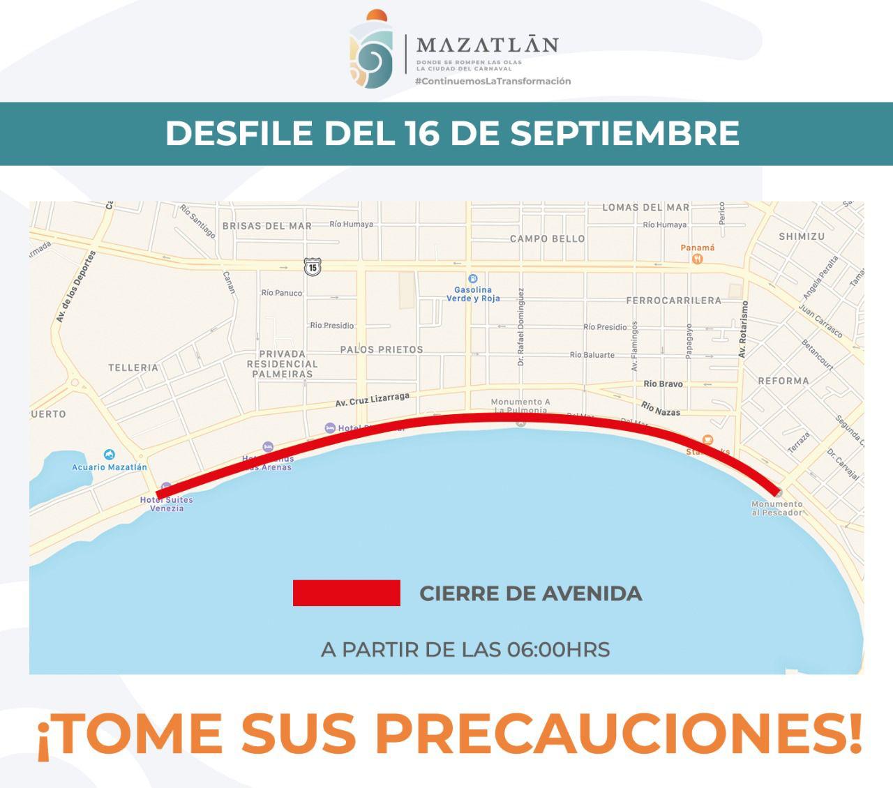
For the Civic Miliary Parade that will take place on September 16, the road operation considers the closure of a section of Del Mar Avenue, starting at 6:00 a.m.
Traffic elements will close road traffic from Gutiérrez Nájera Avenue to De Los Deportes Avenue.
Take an umbrella, there is a forecast of rain
Low pressure is likely to become a tropical cyclone off the coast of Guerrero and Michoacán, so check the weather before you go to give the Cry of Independence

Get ready! Everything seems to indicate that the celebrations of the Independence of Mexico could be accompanied by rains due to a low-pressure zone with the probability of becoming a tropical cyclone over the Pacific Ocean.
Weather forecasts indicate that this week will end with rain and thunderstorms in the northwestern, southeastern, southern and eastern states of the national territory, due to a trough that will extend from the Pacific to the Gulf of Mexico, which would be associated with a Central American Monsoon Gyre.
It is likely that the low pressure will become a tropical cyclone off the coasts of Guerrero and Michoacán for these patriotic days, a condition that will drive humidity into the interior of our country, favoring more rains.
The National Weather System considers this low pressure to have a 70% chance of becoming a tropical cyclone in the next 5 days. Should it become a tropical storm, it would bear the name “Lester.”
For these days, September 15 and 16, very heavy rains (50 to 75 millimeters per day) are forecast in Veracruz, Oaxaca, Guerrero, Michoacán; as well as heavy rains (25 to 50 millimeters per day) in San Luis Potosí, Jalisco, Tabasco, Chiapas, Morelos, State of Mexico, Colima and Sinaloa.
In the rest of the states of the southeast, center, and west of Mexico, light to moderate rains are expected and of a more dispersed nature. The rains would be accompanied by abundant electrical activity and possible hailstorms in some areas, in addition to the fact that some localized puddles or floods are not ruled out.
For today
For Sinaloa, cloudy skies are expected in the morning with showers and electric shocks in Mazatlan. According to the weather report, the port of Mazatlan will have a maximum temperature of 32 degrees Celsius and a minimum of 24 degrees Celsius, with cloudy skies and a 95% chance of rain.


