
The space agency shared an interactive map showing the fires in Mexico and around the world


In the last week Mexico has registered more than 200 forest fires in at least 18 entities, according to the Semarnat, some have suffocated and others are still active, these can be seen from the NASA satellite.


The Fire Information System for Resource Management (FIRMS) shows a map showing the fires that affect Mexico, mainly in the center and south of the country.
Through its social networks, NASA shared another image in which the situation in Jalisco is appreciated, a state in which today classes were suspended due to forest fires, which affect the La Primavera forest.

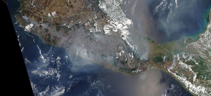


#NASAWorldview Image of the Week: Fires in Southern Mexico, as observed by the NASA Aqua MODIS instrument on 5/12/19. https://go.nasa.gov/2Hhaec8 Interact with image using Worldview:
The high temperatures have put the world on fire, as it has been detected by the National Aeronautics and Space Administration (NASA).

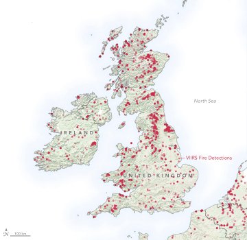

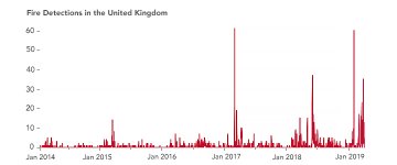
It is not even summertime, but already the United Kingdom has seen a significant number of wildfires.
Through red dots superimposed on the map, NASA designates those regions that have suffered fires in the last hours, days and weeks.


Photo – screenshot
On the map the user can discover each of the fires that take place in different areas of the world and even check their evolution over the days.
Source: el sol de mexico
The Mazatlan Post


")